


LA TOURRETTE

ramsay
User
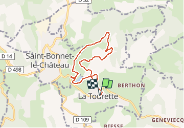

Length
6.7 km

Max alt
821 m

Uphill gradient
173 m
Km-Effort
9.1 km

Min alt
723 m

Downhill gradient
172 m
Boucle
Yes
Creation date :
2018-06-26 13:52:03.63
Updated on :
2018-06-26 13:52:03.63
1h56
Difficulty : Easy

FREE GPS app for hiking
 SityTrail
IGN / Geographical institutes
SityTrail Plus
The world is yours!
About
Trail Walking of 6.7 km to be discovered at Auvergne-Rhône-Alpes, Loire, La Tourette. This trail is proposed by ramsay.
Positioning
Country:
France
Region :
Auvergne-Rhône-Alpes
Department/Province :
Loire
Municipality :
La Tourette
Location:
Unknown
Start:(Dec)
Start:(UTM)
584715 ; 5029652 (31T) N.
Comments